公開日 2021年11月12日
It is said that people started living in Isehara 28,000years ago.Since then until today,people have developed various lives here.
The history of Isehara from its birth to the time when it became Isehara City is introduced here.
Geoigraphical Features of Isehara
Let's take a bird's eye view of Isehara.Mt.Oyama soars 1251.7meters into the sky on the northwest boundary of the city.From there the land gradually becomes lower southeastward where the alluvial plain made by the River Sagami lies.In a word,Isehara has a topography sloping from the northwest to the southeast.
Mountains rise in the northwest area of the city;Hinata and Sannnomiya are hilly;the urban center of Isehara,Okazaki,and Takamori are on the plateau;to their southeast is Ota lying in the flatland which is 10meters high above sea level.In Ishida,Takamori,Shimo-Kasuya,Ikebata,Numame,and Okazaki,tablelands protrude over the lowlands.Odawara-Atsugi Bypass runs on the border between the highlands and the lowlands.Accordingly,most of the rivers flow down southward or eastward from Mt.Oyama.
The topographical diversity,together with ample rainfall and a mild climate,is considered the major factor for Isehara to achieve a long history in which many people have lived since ancient times.
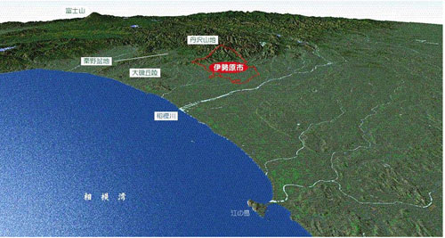
Isehara,located at the southeast end of the Tanzawa mountain range,shows a complex topography with mountains,hills,tablelands,and flatlands.

The picture was made using"3DMap Navigator"based on the 1/25000 map of Tokyo,prepared by the Geoglaphical Survey Institute.
Next⇒Paleolithic Period
- Geogaraphical Features of Isehara
- Paleolithic Period
- Jomon Period
- Yayoi Period
- Kofun (Tumulus)Period
- Nara Period
- Heian Period
- Kamakura Period
- Muromachi Period
- Civil War Period
- Edo Period
- Meiji, Taisho, and Showa Periods


